
| Distance / Altitude | Location | Report Date / Time | Live Weather | Wind | Gusts | Temp. | Visibility | Cloud |
|---|---|---|---|---|---|---|---|---|
| 8 km NW / 0 m | lightning 7km S of Sankt Peter-Ording (Germany) | 2026-06-09 01:02 local (2026/06/08 23:02 GMT) | Thunderstorm | (- km/h at -) | — | |||
| 18 km ESE / 0 m | lightning 6km SE of Busum (Germany) | 2026-06-09 01:33 local (2026/06/08 23:33 GMT) | Thunderstorm | (- km/h at -) | — | |||
| 19 km ENE / 1 m | thunderstorm affecting Wesselburen (Germany) | 2026-06-09 01:36 local (2026/06/08 23:36 GMT) | Thunderstorm | (- km/h at -) | — | |||
| 19 km ESE / 0 m | lightning 7km N of Friedrichskoog (Germany) | 2026-06-09 01:33 local (2026/06/08 23:33 GMT) | Thunderstorm | (- km/h at -) | — | |||
| 19 km E / 1 m | thunderstorm affecting Wohrden (Germany) | 2026-06-09 01:36 local (2026/06/08 23:36 GMT) | Thunderstorm | (- km/h at -) | — | |||
| 22 km NE / 1 m | lightning 5km WNW of Tonning (Germany) | 2026-06-09 01:31 local (2026/06/08 23:31 GMT) | Thunderstorm | (- km/h at -) | — | |||
| 29 km NNE / 0 m | lightning 10km N of Garding (Germany) | 2026-06-09 01:36 local (2026/06/08 23:36 GMT) | Thunderstorm | (- km/h at -) | — | |||
| 30 km S / 15 m | SHIP8499 (Marine) | 2026-06-09 02:00 local (2026/06/09 00:00 GMT) | moderate winds from the W (25.2 km/h at 280) | 18°C | - km | |||
| 30 km S / 15 m | SHIP4507 (Marine) | 2026-06-09 02:00 local (2026/06/09 00:00 GMT) | moderate winds from the W (25.2 km/h at 280) | 18°C | - km | |||
| 30 km S / 15 m | SHIP3630 (Marine) | 2026-06-09 02:00 local (2026/06/09 00:00 GMT) | moderate winds from the W (25.2 km/h at 280) | 18°C | - km |
| Contours: | Roads & Rivers: | Select a
tide station / surf break / city |
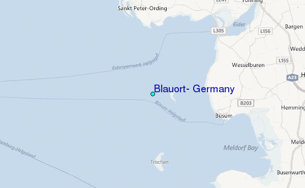
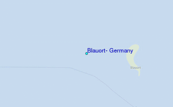
Use this relief map to navigate to tide stations, surf breaks and cities that are in the area of Blauort, Germany.
Other Nearby Locations' tide tables and tide charts to Blauort, Germany:
click location name for more details
 Surf breaks close to Blauort, Germany:
|
||
|---|---|---|
| Closest surf break | St Peter Ording | 12 mi |
| Second closest surf break | Kilometerstein Vier Hornum (Sylt) | 44 mi |
| Third closest surf break | Sansibar Rantum (Sylt) | 50 mi |
| Fourth closest surf break | Oase zur Sonne Westerland (Sylt) | 52 mi |
| Fifth closest surf break | Brandenburg Westerland (Sylt) | 54 mi |


 Nearest
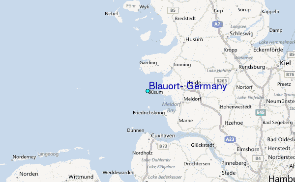