
| Distance / Altitude | Location | Report Date / Time | Live Weather | Wind | Gusts | Temp. | Visibility | Cloud |
|---|---|---|---|---|---|---|---|---|
| 7 km E / 3 m | Eugene F Correira International Airport (Guyana) | 2026-06-09 13:00 local (2026/06/09 17:00 GMT) | Dry and partly cloudy | light winds from the NNE (15 km/h at 20) | 29°C | 10.0 | few scattered broken | |
| 26 km S / 1 m | OgleInternationalAirport (Guyana) | 2026-06-09 13:00 local (2026/06/09 17:00 GMT) | Haze | light winds from the NNE (14 km/h at 20) | 29°C | 30 km | mostly cloudy | |
| 34 km S / 184 m | Georgetown Airport (Guiana) | 2026-06-09 13:00 local (2026/06/09 17:00 GMT) | Shower - in the vicinity | light winds from the NNE.(Wind varies from 330 to 060 degs) (7 km/h at 20) | 26°C | 10.0 | few scattered broken | |
| 236 km WNW / 50 m | Mabaruma (Guyana) | 2026-06-09 14:00 local (2026/06/09 18:00 GMT) | Dry and partly cloudy | wind obs. (22 kph from 150 degs) was rejected (- km/h at -) | 30°C | 10.0 | broken | |
| 348 km N / 3 m | SHIP2122 (Marine) | 2026-06-09 14:00 local (2026/06/09 18:00 GMT) | moderate winds from the NE (26 km/h at 50) | 29°C | 20.4 | |||
| 420 km S / 107 m | Lethem (Guyana) | 2026-06-09 14:00 local (2026/06/09 18:00 GMT) | Dry and partly cloudy | moderate winds from the ENE (22 km/h at 70) | 26°C | 10.0 | scattered | |
| 480 km ESE / 5 m | Saint -Laurent (France) | 2026-06-09 14:00 local (2026/06/09 18:00 GMT) | no report | - (- km/h at -) | 24°C | - | - | |
| 519 km S / 140 m | Boa Vista Airport (Brazil) | 2026-06-09 13:00 local (2026/06/09 17:00 GMT) | Dry and partly cloudy | light winds from the ENE (13 km/h at 70) | 31°C | 10.0 | scattered few scattered | |
| 521 km S / 140 m | Boa Vista (Aero) (Brazil) | 2026-06-09 13:00 local (2026/06/09 17:00 GMT) | no report | calm (4 km/h at 80) | 26°C | 20 | - | |
| 529 km W / 113 m | Ciudad Guayana (Venezuela) | 2026-06-09 14:17 local (2026/06/09 18:17 GMT) | dry | light winds from the NNE (8 km/h at 17) | 30°C | - | - - 0 |
| Contours: | Roads & Rivers: | Select a
tide station / surf break / city |


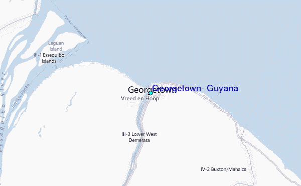
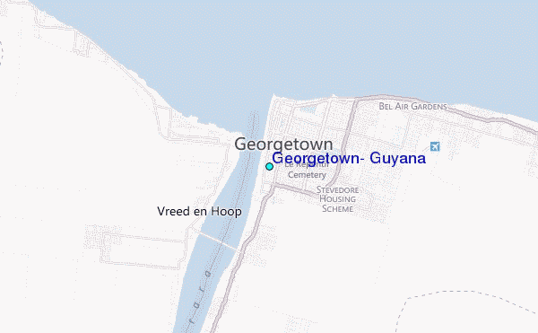
Use this relief map to navigate to tide stations, surf breaks and cities that are in the area of Georgetown, Guyana.
Other Nearby Locations' tide tables and tide charts to Georgetown, Guyana:
click location name for more details
 Surf breaks close to Georgetown, Guyana:
|
||
|---|---|---|
| Closest surf break | The Delta | 275 mi |
| Second closest surf break | Saline Bay | 333 mi |
| Third closest surf break | Salibea Bay | 337 mi |
| Fourth closest surf break | Beach Break | 341 mi |
| Fifth closest surf break | Sans Sousi | 341 mi |


 Nearest
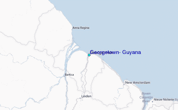