
| Distance / Altitude | Location | Report Date / Time | Live Weather | Wind | Gusts | Temp. | Visibility | Cloud |
|---|---|---|---|---|---|---|---|---|
| 115 km N / 2 m | Roxas (Philippines) | 2026-04-25 08:00 local (2026/04/25 00:00 GMT) | light rain showers | wind obs. (11 kph from 180 degs) was rejected (- km/h at -) | 28°C | 9 | - | |
| 118 km NW / 80 m | Dalipdip wx (Philippines) | 2026-04-25 08:21 local (2026/04/25 00:21 GMT) | dry | light winds from the S (6 km/h at 187) | 28°C | - | - - 0 | |
| 135 km NW / 6 m | Kalibo/panay Isl (Philippines) | 2026-04-25 08:00 local (2026/04/25 00:00 GMT) | Dry and partly cloudy | light winds from the E (19 km/h at 90) | 30°C | 10.0 | scattered | |
| 143 km SSE / 8 m | Dumaguete (Philippines) | 2026-04-25 08:00 local (2026/04/25 00:00 GMT) | distant precipitation but not falling at station | wind obs. (11 kph from 110 degs) was rejected (- km/h at -) | 28°C | 10 | few - - | |
| 143 km SSE / 8 m | Dumaguete–Sibulan Airport (Philippines) | 2026-04-25 08:00 local (2026/04/25 00:00 GMT) | distant precipitation but not falling at station | wind obs. (11 kph from 110 degs) was rejected (- km/h at -) | 28°C | 10 | few - - | |
| 180 km W / 15 m | SHIP9705 (Marine) | 2026-04-25 08:00 local (2026/04/25 00:00 GMT) | fresh winds from the NE (33.480000000000004 km/h at 40) | 29°C | 43.5 km | |||
| 187 km NW / 0 m | Alabat (Philippines) | 2026-04-25 08:00 local (2026/04/25 00:00 GMT) | no report | - (- km/h at -) | 30°C | 25 | - | |
| 205 km WSW / 4 m | Cuyo (Philippines) | 2026-04-25 08:00 local (2026/04/25 00:00 GMT) | state of sky unchanged | wind obs. (7 kph from 200 degs) was rejected (- km/h at -) | 28°C | 15 | - | |
| 217 km NNE / 210 m | Macatan Airport (Philippines) | 2026-04-25 08:00 local (2026/04/25 00:00 GMT) | intermittent light rain | wind obs. (14 kph from 240 degs) was rejected (- km/h at -) | 28°C | 9 | - - - | |
| 218 km NNE / 35 m | Masbate (Philippines) | 2026-04-25 08:00 local (2026/04/25 00:00 GMT) | state of sky unchanged | wind obs. (7 kph from 110 degs) was rejected (- km/h at -) | 30°C | 20 | - |
| Contours: | Roads & Rivers: | Select a
tide station / surf break / city |
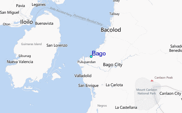
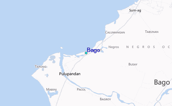
Use this relief map to navigate to tide stations, surf breaks and cities that are in the area of Bago.
Other Nearby Locations' tide tables and tide charts to Bago:
click location name for more details
 Surf breaks close to Bago:
|
||
|---|---|---|
| Closest surf break | Boulevard | 190 mi |
| Second closest surf break | Guitagican Beach | 190 mi |
| Third closest surf break | Pirates Cove | 190 mi |
| Fourth closest surf break | Llorente | 192 mi |
| Fifth closest surf break | Santa Monica | 193 mi |


 Nearest
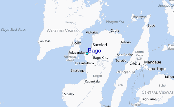