
| Distance / Altitude | Location | Report Date / Time | Live Weather | Wind | Gusts | Temp. | Visibility | Cloud |
|---|---|---|---|---|---|---|---|---|
| 34 km WNW / 229 m | Savoonga Airport (Alaska) | 2025-12-25 09:56 local (2025/12/25 19:56 GMT) | Dry and cloudy | light winds from the NE (7 km/h at 40) | -7°C | 16 | overcast | |
| 91 km W / 3 m | BUOY-GBXA2 (Marine) | 2025-12-25 11:32 local (2025/12/25 21:32 GMT) | light winds from the SSW (13 km/h at 200) | -7°C | - | |||
| 91 km W / 347 m | Gambell Airport (Alaska) | 2025-12-25 09:56 local (2025/12/25 19:56 GMT) | Dry and cloudy | light winds from the SSE (9 km/h at 150) | -7°C | 16 | overcast | |
| 251 km ENE / 3 m | BUOY-NMXA2 (Marine) | 2025-12-25 11:32 local (2025/12/25 21:32 GMT) | light winds from the NE (13 km/h at 50) | -16°C | - | |||
| 252 km ENE / 3 m | BUOY-NMTA2 (Marine) | 2025-12-25 11:00 local (2025/12/25 21:00 GMT) | light winds from the ENE (11 km/h at 70) | -16°C | - | |||
| 252 km ENE / 214 m | Nome Airport (Alaska) | 2025-12-25 09:53 local (2025/12/25 19:53 GMT) | Dry and cloudy | light winds from the E (17 km/h at 80) | -16°C | 16 | overcast | |
| 257 km NNE / 7 m | Wales Airport (Alaska) | 2025-12-25 09:56 local (2025/12/25 19:56 GMT) | Dry and cloudy | light winds from the NE (7 km/h at 40) | -13°C | 16 | overcast | |
| 263 km ENE / 16 m | Nome (Alaska) | 2025-12-25 10:02 local (2025/12/25 20:02 GMT) | - | calm (3 km/h at 330) | -21°C | - | - - 0 | |
| 263 km ENE / 11 m | Nome (Alaska) | 2025-12-25 11:37 local (2025/12/25 21:37 GMT) | - | calm (0 km/h at 0) | -19°C | - | - - 0 | |
| 265 km NE / 90 m | Teller Airport (Alaska) | 2025-12-25 09:56 local (2025/12/25 19:56 GMT) | Light snow | light winds from the SE (9 km/h at 140) | -14°C | 13 | overcast |
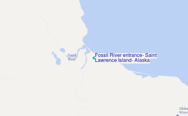
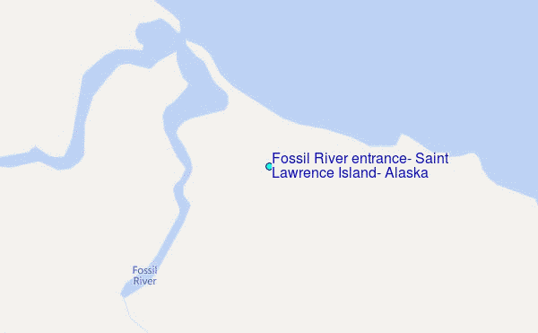
Choose Fossil River entrance, Saint Lawrence Island, Alaska Location Map Zoom:
| Contours: | Roads & Rivers: | Select a
tide station / surf break / city |
Use this relief map to navigate to tide stations, surf breaks and cities that are in the area of Fossil River entrance, Saint Lawrence Island, Alaska.
Other Nearby Locations' tide tables and tide charts to Fossil River entrance, Saint Lawrence Island, Alaska:
click location name for more details
 Surf breaks close to Fossil River entrance, Saint Lawrence Island, Alaska:
|
||
|---|---|---|
| Closest surf break | Bird Point (Tidal Bore) | 630 mi |
| Second closest surf break | Termination Point | 708 mi |
| Third closest surf break | Monashka Bay | 709 mi |
| Fourth closest surf break | Mill Bay | 711 mi |
| Fifth closest surf break | Fossil Beach Kodiak | 729 mi |


 Nearest
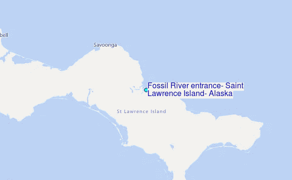