
| Distance / Altitude | Location | Report Date / Time | Live Weather | Wind | Gusts | Temp. | Visibility | Cloud |
|---|---|---|---|---|---|---|---|---|
| 41 km E / 15 m | ASCATC143E10S (Marine) | 2025-12-24 09:31 local (2025/12/23 23:31 GMT) | calm (4 km/h at 196) | — | - km | |||
| 46 km N / 15 m | SHIP2758 (Marine) | 2025-12-24 11:00 local (2025/12/24 01:00 GMT) | light winds from the ESE (14.4 km/h at 120) | 30°C | - km | |||
| 50 km NE / 4 m | Coconut Island (Australia) | 2025-12-24 12:00 local (2025/12/24 02:00 GMT) | no report | - (- km/h at -) | 26°C | - | - | |
| 58 km SW / 13 m | Horn Island Airport (Australia) | 2025-12-24 11:30 local (2025/12/24 01:30 GMT) | Heavy rain | wind obs. (9 kph from 220 degs) was rejected (- km/h at -) | 28°C | 0.0 | scattered broken broken | |
| 59 km SW / 5 m | Horn Island Automatic Weather Station (Australia) | 2025-12-24 11:00 local (2025/12/24 01:00 GMT) | no report | wind obs. (9 kph from 50 degs) was rejected (- km/h at -) | 31°C | - | - no observation - | |
| 57 km N / 15 m | SHIP7476 (Marine) | 2025-12-24 10:00 local (2025/12/24 00:00 GMT) | - (- km/h at -) | 30°C | - km | |||
| 57 km N / 15 m | SHIP9526 (Marine) | 2025-12-24 10:00 local (2025/12/24 00:00 GMT) | - (- km/h at -) | 30°C | - km | |||
| 57 km N / 3 m | SHIP8488 (Marine) | 2025-12-24 10:00 local (2025/12/24 00:00 GMT) | - (- km/h at -) | 28°C | - | |||
| 58 km SW / 13 m | Horn Island Airport (Australia) | 2025-12-24 11:30 local (2025/12/24 01:30 GMT) | Heavy rain | wind obs. (9 kph from 220 degs) was rejected (- km/h at -) | 28°C | 0.0 | scattered broken broken | |
| 59 km SW / 5 m | Horn Island Automatic Weather Station (Australia) | 2025-12-24 11:00 local (2025/12/24 01:00 GMT) | no report | wind obs. (9 kph from 50 degs) was rejected (- km/h at -) | 31°C | - | - no observation - |
| Contours: | Roads & Rivers: | Select a
tide station / surf break / city |
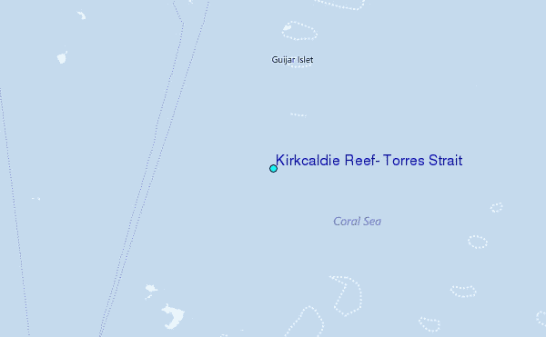
Use this relief map to navigate to tide stations, surf breaks and cities that are in the area of Kirkcaldie Reef, Torres Strait.
Other Nearby Locations' tide tables and tide charts to Kirkcaldie Reef, Torres Strait:
click location name for more details
 Surf breaks close to Kirkcaldie Reef, Torres Strait:
|
||
|---|---|---|
| Closest surf break | Tupira Right | 450 mi |
| Second closest surf break | Forok Point | 474 mi |
| Third closest surf break | The Wharf (Mission Point) | 477 mi |
| Fourth closest surf break | Wewak Point | 478 mi |
| Fifth closest surf break | Moem Point | 479 mi |


 Nearest
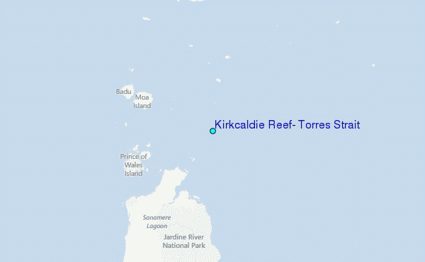