
Today's tide times for Pea Patch Island, Bulkhead Shoal Channel, Chesapeake and Delaware Canal, Delaware
The predicted tide times today on Tuesday 23 June 2026 for Pea Patch Island, Bulkhead Shoal Channel, Chesapeake and Delaware Canal are: first low tide at 1:17am, first high tide at 7:04am, second low tide at 1:37pm, second high tide at 7:40pm. Sunrise is at 5:35am and sunset is at 8:33pm.
Today's tide times for Pea Patch Island, Bulkhead Shoal Channel, Chesapeake and Delaware Canal: Tuesday 23 June 2026
| Tide | Time (EDT)& Date | Height |
|---|---|---|
| Low Tide | 1:17 AM(Tue 23 June) | 0.82 ft (0.25 m) |
| High Tide | 7:04 AM(Tue 23 June) | 5.58 ft (1.7 m) |
| Low Tide | 1:37 PM(Tue 23 June) | 0.44 ft (0.13 m) |
| High Tide | 7:40 PM(Tue 23 June) | 6.1 ft (1.86 m) |
- Wind Speed
- Swell
- Weather

Tide chart for Pea Patch Island, Bulkhead Shoal Channel, Chesapeake and Delaware CanalShowing low and high tide times for the next 30 days at Pea Patch Island, Bulkhead Shoal Channel, Chesapeake and Delaware Canal. Tide Times are EDT (UTC -4.0hrs).
View Pea Patch Island, Bulkhead Shoal Channel, Chesapeake and Delaware Canal 7 Day Tide Chart Image.
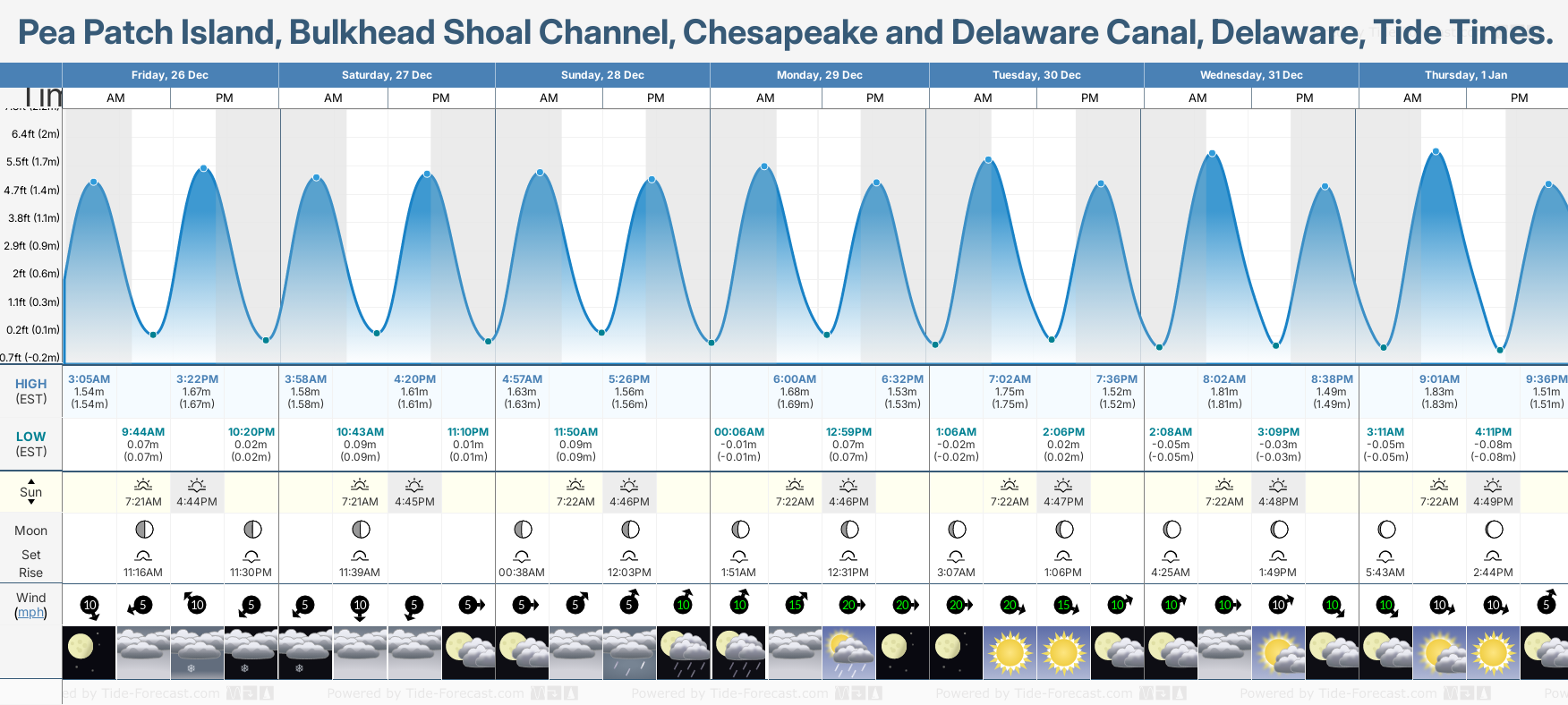
 to expand the day into detailed view, Click Tap any to view the height and time.
HIGH (EDT) |
LOW (EDT) |
| Sun |
Moon Set Rise |
| Wind |
Tuesday, 23 Jun | 24 Jun | 25 Jun | 26 Jun | 27 Jun | 28 Jun | 29 Jun | 30 Jun | 1 Jul | 2 Jul | 3 Jul | 4 Jul | 5 Jul | 6 Jul | 7 Jul | 8 Jul | 9 Jul | 10 Jul | 11 Jul | 12 Jul | 13 Jul | 14 Jul | 15 Jul | 16 Jul | 17 Jul | 18 Jul | 19 Jul | 20 Jul | 21 Jul | 22 Jul | |||
|---|---|---|---|---|---|---|---|---|---|---|---|---|---|---|---|---|---|---|---|---|---|---|---|---|---|---|---|---|---|---|---|---|
| AM | PM | Wed | Thu | Fri | Sat | Sun | Mon | Tue | Wed | Thu | Fri | Sat | Sun | Mon | Tue | Wed | Thu | Fri | Sat | Sun | Mon | Tue | Wed | Thu | Fri | Sat | Sun | Mon | Tue | Wed | ||
7:04AM1.70m | 7:40PM1.86m | 7:59AM1.67m 8:31PM1.90m | 8:52AM1.66m 9:19PM1.94m | 9:43AM1.65m 10:05PM1.96m | 10:31AM1.64m 10:49PM1.97m | 11:17AM1.63m 11:31PM1.96m | 12:00PM1.61m | 00:10AM1.95m 12:41PM1.60m | 00:47AM1.93m 1:19PM1.59m | 1:22AM1.92m 1:54PM1.60m | 1:54AM1.91m 2:28PM1.63m | 2:28AM1.90m 3:03PM1.67m | 3:05AM1.87m 3:41PM1.72m | 3:49AM1.83m 4:27PM1.77m | 4:41AM1.77m 5:20PM1.82m | 5:42AM1.70m 6:20PM1.87m | 6:49AM1.64m 7:23PM1.92m | 7:57AM1.61m 8:25PM1.98m | 9:02AM1.61m 9:26PM2.02m | 10:03AM1.63m 10:25PM2.06m | 11:02AM1.65m 11:21PM2.08m | 11:59AM1.69m | 00:17AM2.08m 12:54PM1.73m | 1:10AM2.06m 1:47PM1.76m | 2:01AM2.01m 2:39PM1.78m | 2:52AM1.94m 3:30PM1.80m | 3:44AM1.86m 4:22PM1.80m | 4:36AM1.78m 5:14PM1.81m | 5:31AM1.70m 6:07PM1.81m | 6:28AM1.64m 7:01PM1.83m | ||
1:17AM0.25m | 1:37PM0.13m | 2:14AM0.23m 2:26PM0.16m | 3:09AM0.21m 3:14PM0.17m | 4:02AM0.17m 4:01PM0.18m | 4:52AM0.15m 4:46PM0.20m | 5:39AM0.14m 5:30PM0.20m | 6:24AM0.14m 6:13PM0.21m | 7:06AM0.14m 6:54PM0.22m | 7:46AM0.16m 7:33PM0.23m | 8:24AM0.16m 8:11PM0.24m | 8:59AM0.17m 8:50PM0.25m | 9:34AM0.17m 9:30PM0.26m | 10:08AM0.16m 10:16PM0.28m | 10:45AM0.16m 11:10PM0.30m | 11:27AM0.16m | 00:13AM0.32m 12:18PM0.16m | 1:23AM0.31m 1:17PM0.17m | 2:32AM0.28m 2:22PM0.17m | 3:39AM0.23m 3:29PM0.16m | 4:41AM0.16m 4:33PM0.13m | 5:40AM0.08m 5:34PM0.10m | 6:35AM0.02m 6:32PM0.08m | 7:27AM-0.02m 7:27PM0.07m | 8:17AM-0.04m 8:20PM0.08m | 9:04AM-0.03m 9:12PM0.11m | 9:50AM-0.00m 10:04PM0.15m | 10:35AM0.04m 10:56PM0.20m | 11:20AM0.10m 11:49PM0.24m | 12:06PM0.15m | 00:44AM0.27m 12:54PM0.20m | ||
 5:35AM |  8:33PM | 5:35AM 8:33PM | 5:36AM 8:33PM | 5:36AM 8:33PM | 5:36AM 8:33PM | 5:37AM 8:33PM | 5:37AM 8:33PM | 5:38AM 8:33PM | 5:38AM 8:33PM | 5:39AM 8:33PM | 5:39AM 8:33PM | 5:40AM 8:33PM | 5:40AM 8:32PM | 5:41AM 8:32PM | 5:41AM 8:32PM | 5:42AM 8:32PM | 5:43AM 8:31PM | 5:43AM 8:31PM | 5:44AM 8:30PM | 5:45AM 8:30PM | 5:46AM 8:29PM | 5:46AM 8:29PM | 5:47AM 8:28PM | 5:48AM 8:28PM | 5:49AM 8:27PM | 5:49AM 8:26PM | 5:50AM 8:26PM | 5:51AM 8:25PM | 5:52AM 8:24PM | 5:53AM 8:24PM | ||
0.3% - (Waxing Gibbous)  1:19AM | 0.31% - (Waxing Gibbous)  3:02PM | 0.35% - (Waxing Gibbous) 1:43AM 4:04PM | 0.39% - (Waxing Gibbous) 2:09AM 5:07PM | 0.42% - (Waxing Gibbous) 2:40AM 6:09PM | 0.46% - (Waxing Gibbous) 3:17AM 7:08PM | 0.49% - (Full Moon) 4:00AM 8:02PM | 0.53% - (Full Moon) 4:51AM 8:49PM | 0.56% - (Waning Gibbous) 5:49AM 9:30PM | 0.6% - (Waning Gibbous) 6:50AM 10:03PM | 0.63% - (Waning Gibbous) 7:54AM 10:32PM | 0.66% - (Waning Gibbous) 8:57AM 10:57PM | 0.7% - (Waning Gibbous) 10:01AM 11:20PM | 0.73% - (Last Quarter) 11:04AM 11:42PM | 0.75% - (Last Quarter) 12:09PM | 0.77% - (Last Quarter) 1:16PM 00:04AM | 0.8% - (Waning Crescent) 2:27PM 00:29AM | 0.84% - (Waning Crescent) 3:41PM 00:58AM | 0.87% - (Waning Crescent) 4:58PM 1:33AM | 0.91% - (Waning Crescent) 6:14PM 2:17AM | 0.94% - (Waning Crescent) 7:23PM 3:14AM | 0.98% - (New Moon) 8:20PM 4:24AM | 0.03% - (Waxing Crescent) 9:06PM 5:41AM | 0.07% - (Waxing Crescent) 9:41PM 7:01AM | 0.1% - (Waxing Crescent) 10:11PM 8:18AM | 0.14% - (Waxing Crescent) 10:36PM 9:31AM | 0.17% - (Waxing Crescent) 10:59PM 10:40AM | 0.21% - (Waxing Crescent) 11:22PM 11:47AM | 0.24% - (First Quarter) 11:45PM 12:51PM | 0.28% - (First Quarter) 1:55PM | 0.31% - (Waxing Gibbous) 00:11AM 2:58PM | ||

Pea Patch Island, Bulkhead Shoal Channel, Chesapeake and Delaware Canal tide chart key:
The tide chart above shows the height and times of high tide and low tide for Pea Patch Island, Bulkhead Shoal Channel, Chesapeake and Delaware Canal, Delaware. The red flashing dot shows the tide time right now. The grey shading corresponds to nighttime hours between sunset and sunrise at Pea Patch Island, Bulkhead Shoal Channel, Chesapeake and Delaware Canal.
Tide Times are EDT (UTC -4.0hrs). Last Spring High Tide at Pea Patch Island, Bulkhead Shoal Channel, Chesapeake and Delaware Canal was on Mon 15 Jun (height: 2.12m 7.0ft). Next high Spring Tide at Pea Patch Island, Bulkhead Shoal Channel, Chesapeake and Delaware Canal will be on Sat 27 Jun (height: 1.97m 6.5ft).
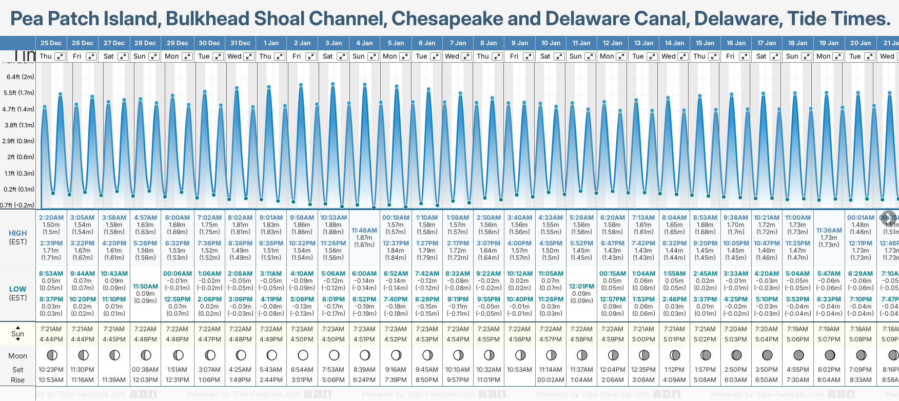
Pea Patch Island, Bulkhead Shoal Channel, Chesapeake and Delaware Canal tide chart key: The tide chart above shows the height and times of high tide and low tide for Pea Patch Island, Bulkhead Shoal Channel, Chesapeake and Delaware Canal, Delaware. The grey shading corresponds to nighttime hours between sunset and sunrise at Pea Patch Island, Bulkhead Shoal Channel, Chesapeake and Delaware Canal.
Tide Times are EDT (UTC -4.0hrs). Last Spring High Tide at Pea Patch Island, Bulkhead Shoal Channel, Chesapeake and Delaware Canal was on Mon 15 Jun (height: 2.12m 7.0ft). Next high Spring Tide at Pea Patch Island, Bulkhead Shoal Channel, Chesapeake and Delaware Canal will be on Sat 27 Jun (height: 1.97m 6.5ft).
Pea Patch Island, Bulkhead Shoal Channel, Chesapeake and Delaware Canal tide times for June and July
June and July Tide charts for Pea Patch Island, Bulkhead Shoal Channel, Chesapeake and Delaware Canal: The tide charts below show the height, time and date of high and low tides for the next 30 days.
Tide Times for Pea Patch Island, Bulkhead Shoal Channel, Chesapeake and Delaware Canal (tomorrow): Wednesday 24 June 2026
| Tide | Time (EDT)& Date | Height |
|---|---|---|
| Low Tide | 2:14 AM(Wed 24 June) | 0.77 ft (0.23 m) |
| High Tide | 7:59 AM(Wed 24 June) | 5.49 ft (1.67 m) |
| Low Tide | 2:26 PM(Wed 24 June) | 0.51 ft (0.16 m) |
| High Tide | 8:31 PM(Wed 24 June) | 6.24 ft (1.9 m) |
Powered by Tide-Forecast.com
Tide Times for Pea Patch Island, Bulkhead Shoal Channel, Chesapeake and Delaware Canal: Thursday 25 June 2026
| Tide | Time (EDT)& Date | Height |
|---|---|---|
| Low Tide | 3:09 AM(Thu 25 June) | 0.68 ft (0.21 m) |
| High Tide | 8:52 AM(Thu 25 June) | 5.45 ft (1.66 m) |
| Low Tide | 3:14 PM(Thu 25 June) | 0.56 ft (0.17 m) |
| High Tide | 9:19 PM(Thu 25 June) | 6.35 ft (1.94 m) |
Powered by Tide-Forecast.com
Tide Times for Pea Patch Island, Bulkhead Shoal Channel, Chesapeake and Delaware Canal: Friday 26 June 2026
| Tide | Time (EDT)& Date | Height |
|---|---|---|
| Low Tide | 4:02 AM(Fri 26 June) | 0.57 ft (0.17 m) |
| High Tide | 9:43 AM(Fri 26 June) | 5.42 ft (1.65 m) |
| Low Tide | 4:01 PM(Fri 26 June) | 0.6 ft (0.18 m) |
| High Tide | 10:05 PM(Fri 26 June) | 6.42 ft (1.96 m) |
Powered by Tide-Forecast.com
Tide Times for Pea Patch Island, Bulkhead Shoal Channel, Chesapeake and Delaware Canal: Saturday 27 June 2026
| Tide | Time (EDT)& Date | Height |
|---|---|---|
| Low Tide | 4:52 AM(Sat 27 June) | 0.49 ft (0.15 m) |
| High Tide | 10:31 AM(Sat 27 June) | 5.39 ft (1.64 m) |
| Low Tide | 4:46 PM(Sat 27 June) | 0.64 ft (0.2 m) |
| High Tide | 10:49 PM(Sat 27 June) | 6.45 ft (1.97 m) |
Powered by Tide-Forecast.com
Tide Times for Pea Patch Island, Bulkhead Shoal Channel, Chesapeake and Delaware Canal: Sunday 28 June 2026
| Tide | Time (EDT)& Date | Height |
|---|---|---|
| Low Tide | 5:39 AM(Sun 28 June) | 0.45 ft (0.14 m) |
| High Tide | 11:17 AM(Sun 28 June) | 5.35 ft (1.63 m) |
| Low Tide | 5:30 PM(Sun 28 June) | 0.67 ft (0.2 m) |
| High Tide | 11:31 PM(Sun 28 June) | 6.43 ft (1.96 m) |
Powered by Tide-Forecast.com
Tide Times for Pea Patch Island, Bulkhead Shoal Channel, Chesapeake and Delaware Canal: Monday 29 June 2026
| Tide | Time (EDT)& Date | Height |
|---|---|---|
| Low Tide | 6:24 AM(Mon 29 June) | 0.45 ft (0.14 m) |
| High Tide | 12:00 PM(Mon 29 June) | 5.3 ft (1.61 m) |
| Low Tide | 6:13 PM(Mon 29 June) | 0.7 ft (0.21 m) |
Powered by Tide-Forecast.com
Tide Times for Pea Patch Island, Bulkhead Shoal Channel, Chesapeake and Delaware Canal: Tuesday 30 June 2026
| Tide | Time (EDT)& Date | Height |
|---|---|---|
| High Tide | 00:10 AM(Tue 30 June) | 6.39 ft (1.95 m) |
| Low Tide | 7:06 AM(Tue 30 June) | 0.47 ft (0.14 m) |
| High Tide | 12:41 PM(Tue 30 June) | 5.25 ft (1.6 m) |
| Low Tide | 6:54 PM(Tue 30 June) | 0.73 ft (0.22 m) |
Powered by Tide-Forecast.com
Tide Times for Pea Patch Island, Bulkhead Shoal Channel, Chesapeake and Delaware Canal: Wednesday 01 July 2026
| Tide | Time (EDT)& Date | Height |
|---|---|---|
| High Tide | 00:47 AM(Wed 01 July) | 6.34 ft (1.93 m) |
| Low Tide | 7:46 AM(Wed 01 July) | 0.51 ft (0.16 m) |
| High Tide | 1:19 PM(Wed 01 July) | 5.22 ft (1.59 m) |
| Low Tide | 7:33 PM(Wed 01 July) | 0.75 ft (0.23 m) |
Powered by Tide-Forecast.com
Tide Times for Pea Patch Island, Bulkhead Shoal Channel, Chesapeake and Delaware Canal: Thursday 02 July 2026
| Tide | Time (EDT)& Date | Height |
|---|---|---|
| High Tide | 1:22 AM(Thu 02 July) | 6.3 ft (1.92 m) |
| Low Tide | 8:24 AM(Thu 02 July) | 0.54 ft (0.16 m) |
| High Tide | 1:54 PM(Thu 02 July) | 5.25 ft (1.6 m) |
| Low Tide | 8:11 PM(Thu 02 July) | 0.78 ft (0.24 m) |
Powered by Tide-Forecast.com
Tide Times for Pea Patch Island, Bulkhead Shoal Channel, Chesapeake and Delaware Canal: Friday 03 July 2026
| Tide | Time (EDT)& Date | Height |
|---|---|---|
| High Tide | 1:54 AM(Fri 03 July) | 6.26 ft (1.91 m) |
| Low Tide | 8:59 AM(Fri 03 July) | 0.56 ft (0.17 m) |
| High Tide | 2:28 PM(Fri 03 July) | 5.34 ft (1.63 m) |
| Low Tide | 8:50 PM(Fri 03 July) | 0.81 ft (0.25 m) |
Powered by Tide-Forecast.com
Tide Times for Pea Patch Island, Bulkhead Shoal Channel, Chesapeake and Delaware Canal: Saturday 04 July 2026
| Tide | Time (EDT)& Date | Height |
|---|---|---|
| High Tide | 2:28 AM(Sat 04 July) | 6.22 ft (1.9 m) |
| Low Tide | 9:34 AM(Sat 04 July) | 0.55 ft (0.17 m) |
| High Tide | 3:03 PM(Sat 04 July) | 5.48 ft (1.67 m) |
| Low Tide | 9:30 PM(Sat 04 July) | 0.85 ft (0.26 m) |
Powered by Tide-Forecast.com
Tide Times for Pea Patch Island, Bulkhead Shoal Channel, Chesapeake and Delaware Canal: Sunday 05 July 2026
| Tide | Time (EDT)& Date | Height |
|---|---|---|
| High Tide | 3:05 AM(Sun 05 July) | 6.15 ft (1.87 m) |
| Low Tide | 10:08 AM(Sun 05 July) | 0.53 ft (0.16 m) |
| High Tide | 3:41 PM(Sun 05 July) | 5.65 ft (1.72 m) |
| Low Tide | 10:16 PM(Sun 05 July) | 0.91 ft (0.28 m) |
Powered by Tide-Forecast.com
Tide Times for Pea Patch Island, Bulkhead Shoal Channel, Chesapeake and Delaware Canal: Monday 06 July 2026
| Tide | Time (EDT)& Date | Height |
|---|---|---|
| High Tide | 3:49 AM(Mon 06 July) | 6.01 ft (1.83 m) |
| Low Tide | 10:45 AM(Mon 06 July) | 0.51 ft (0.16 m) |
| High Tide | 4:27 PM(Mon 06 July) | 5.82 ft (1.77 m) |
| Low Tide | 11:10 PM(Mon 06 July) | 0.98 ft (0.3 m) |
Powered by Tide-Forecast.com
Tide Times for Pea Patch Island, Bulkhead Shoal Channel, Chesapeake and Delaware Canal: Tuesday 07 July 2026
| Tide | Time (EDT)& Date | Height |
|---|---|---|
| High Tide | 4:41 AM(Tue 07 July) | 5.8 ft (1.77 m) |
| Low Tide | 11:27 AM(Tue 07 July) | 0.51 ft (0.16 m) |
| High Tide | 5:20 PM(Tue 07 July) | 5.98 ft (1.82 m) |
Powered by Tide-Forecast.com
Tide Times for Pea Patch Island, Bulkhead Shoal Channel, Chesapeake and Delaware Canal: Wednesday 08 July 2026
| Tide | Time (EDT)& Date | Height |
|---|---|---|
| Low Tide | 00:13 AM(Wed 08 July) | 1.04 ft (0.32 m) |
| High Tide | 5:42 AM(Wed 08 July) | 5.57 ft (1.7 m) |
| Low Tide | 12:18 PM(Wed 08 July) | 0.53 ft (0.16 m) |
| High Tide | 6:20 PM(Wed 08 July) | 6.14 ft (1.87 m) |
Powered by Tide-Forecast.com
Tide Times for Pea Patch Island, Bulkhead Shoal Channel, Chesapeake and Delaware Canal: Thursday 09 July 2026
| Tide | Time (EDT)& Date | Height |
|---|---|---|
| Low Tide | 1:23 AM(Thu 09 July) | 1.03 ft (0.31 m) |
| High Tide | 6:49 AM(Thu 09 July) | 5.39 ft (1.64 m) |
| Low Tide | 1:17 PM(Thu 09 July) | 0.55 ft (0.17 m) |
| High Tide | 7:23 PM(Thu 09 July) | 6.3 ft (1.92 m) |
Powered by Tide-Forecast.com
Tide Times for Pea Patch Island, Bulkhead Shoal Channel, Chesapeake and Delaware Canal: Friday 10 July 2026
| Tide | Time (EDT)& Date | Height |
|---|---|---|
| Low Tide | 2:32 AM(Fri 10 July) | 0.93 ft (0.28 m) |
| High Tide | 7:57 AM(Fri 10 July) | 5.29 ft (1.61 m) |
| Low Tide | 2:22 PM(Fri 10 July) | 0.56 ft (0.17 m) |
| High Tide | 8:25 PM(Fri 10 July) | 6.48 ft (1.98 m) |
Powered by Tide-Forecast.com
Tide Times for Pea Patch Island, Bulkhead Shoal Channel, Chesapeake and Delaware Canal: Saturday 11 July 2026
| Tide | Time (EDT)& Date | Height |
|---|---|---|
| Low Tide | 3:39 AM(Sat 11 July) | 0.74 ft (0.23 m) |
| High Tide | 9:02 AM(Sat 11 July) | 5.28 ft (1.61 m) |
| Low Tide | 3:29 PM(Sat 11 July) | 0.52 ft (0.16 m) |
| High Tide | 9:26 PM(Sat 11 July) | 6.64 ft (2.02 m) |
Powered by Tide-Forecast.com
Tide Times for Pea Patch Island, Bulkhead Shoal Channel, Chesapeake and Delaware Canal: Sunday 12 July 2026
| Tide | Time (EDT)& Date | Height |
|---|---|---|
| Low Tide | 4:41 AM(Sun 12 July) | 0.51 ft (0.16 m) |
| High Tide | 10:03 AM(Sun 12 July) | 5.34 ft (1.63 m) |
| Low Tide | 4:33 PM(Sun 12 July) | 0.44 ft (0.13 m) |
| High Tide | 10:25 PM(Sun 12 July) | 6.77 ft (2.06 m) |
Powered by Tide-Forecast.com
Tide Times for Pea Patch Island, Bulkhead Shoal Channel, Chesapeake and Delaware Canal: Monday 13 July 2026
| Tide | Time (EDT)& Date | Height |
|---|---|---|
| Low Tide | 5:40 AM(Mon 13 July) | 0.27 ft (0.08 m) |
| High Tide | 11:02 AM(Mon 13 July) | 5.43 ft (1.65 m) |
| Low Tide | 5:34 PM(Mon 13 July) | 0.34 ft (0.1 m) |
| High Tide | 11:21 PM(Mon 13 July) | 6.83 ft (2.08 m) |
Powered by Tide-Forecast.com
Tide Times for Pea Patch Island, Bulkhead Shoal Channel, Chesapeake and Delaware Canal: Tuesday 14 July 2026
| Tide | Time (EDT)& Date | Height |
|---|---|---|
| Low Tide | 6:35 AM(Tue 14 July) | 0.07 ft (0.02 m) |
| High Tide | 11:59 AM(Tue 14 July) | 5.55 ft (1.69 m) |
| Low Tide | 6:32 PM(Tue 14 July) | 0.26 ft (0.08 m) |
Powered by Tide-Forecast.com
Tide Times for Pea Patch Island, Bulkhead Shoal Channel, Chesapeake and Delaware Canal: Wednesday 15 July 2026
| Tide | Time (EDT)& Date | Height |
|---|---|---|
| High Tide | 00:17 AM(Wed 15 July) | 6.83 ft (2.08 m) |
| Low Tide | 7:27 AM(Wed 15 July) | -0.07 ft (-0.02 m) |
| High Tide | 12:54 PM(Wed 15 July) | 5.66 ft (1.73 m) |
| Low Tide | 7:27 PM(Wed 15 July) | 0.23 ft (0.07 m) |
Powered by Tide-Forecast.com
Tide Times for Pea Patch Island, Bulkhead Shoal Channel, Chesapeake and Delaware Canal: Thursday 16 July 2026
| Tide | Time (EDT)& Date | Height |
|---|---|---|
| High Tide | 1:10 AM(Thu 16 July) | 6.75 ft (2.06 m) |
| Low Tide | 8:17 AM(Thu 16 July) | -0.13 ft (-0.04 m) |
| High Tide | 1:47 PM(Thu 16 July) | 5.76 ft (1.76 m) |
| Low Tide | 8:20 PM(Thu 16 July) | 0.26 ft (0.08 m) |
Powered by Tide-Forecast.com
Tide Times for Pea Patch Island, Bulkhead Shoal Channel, Chesapeake and Delaware Canal: Friday 17 July 2026
| Tide | Time (EDT)& Date | Height |
|---|---|---|
| High Tide | 2:01 AM(Fri 17 July) | 6.6 ft (2.01 m) |
| Low Tide | 9:04 AM(Fri 17 July) | -0.11 ft (-0.03 m) |
| High Tide | 2:39 PM(Fri 17 July) | 5.84 ft (1.78 m) |
| Low Tide | 9:12 PM(Fri 17 July) | 0.36 ft (0.11 m) |
Powered by Tide-Forecast.com
Tide Times for Pea Patch Island, Bulkhead Shoal Channel, Chesapeake and Delaware Canal: Saturday 18 July 2026
| Tide | Time (EDT)& Date | Height |
|---|---|---|
| High Tide | 2:52 AM(Sat 18 July) | 6.38 ft (1.94 m) |
| Low Tide | 9:50 AM(Sat 18 July) | -0.01 ft (-0.0 m) |
| High Tide | 3:30 PM(Sat 18 July) | 5.89 ft (1.8 m) |
| Low Tide | 10:04 PM(Sat 18 July) | 0.5 ft (0.15 m) |
Powered by Tide-Forecast.com
Tide Times for Pea Patch Island, Bulkhead Shoal Channel, Chesapeake and Delaware Canal: Sunday 19 July 2026
| Tide | Time (EDT)& Date | Height |
|---|---|---|
| High Tide | 3:44 AM(Sun 19 July) | 6.11 ft (1.86 m) |
| Low Tide | 10:35 AM(Sun 19 July) | 0.14 ft (0.04 m) |
| High Tide | 4:22 PM(Sun 19 July) | 5.91 ft (1.8 m) |
| Low Tide | 10:56 PM(Sun 19 July) | 0.66 ft (0.2 m) |
Powered by Tide-Forecast.com
Tide Times for Pea Patch Island, Bulkhead Shoal Channel, Chesapeake and Delaware Canal: Monday 20 July 2026
| Tide | Time (EDT)& Date | Height |
|---|---|---|
| High Tide | 4:36 AM(Mon 20 July) | 5.83 ft (1.78 m) |
| Low Tide | 11:20 AM(Mon 20 July) | 0.32 ft (0.1 m) |
| High Tide | 5:14 PM(Mon 20 July) | 5.93 ft (1.81 m) |
| Low Tide | 11:49 PM(Mon 20 July) | 0.8 ft (0.24 m) |
Powered by Tide-Forecast.com
Tide Times for Pea Patch Island, Bulkhead Shoal Channel, Chesapeake and Delaware Canal: Tuesday 21 July 2026
| Tide | Time (EDT)& Date | Height |
|---|---|---|
| High Tide | 5:31 AM(Tue 21 July) | 5.57 ft (1.7 m) |
| Low Tide | 12:06 PM(Tue 21 July) | 0.5 ft (0.15 m) |
| High Tide | 6:07 PM(Tue 21 July) | 5.95 ft (1.81 m) |
Powered by Tide-Forecast.com
Tide Times for Pea Patch Island, Bulkhead Shoal Channel, Chesapeake and Delaware Canal: Wednesday 22 July 2026
| Tide | Time (EDT)& Date | Height |
|---|---|---|
| Low Tide | 00:44 AM(Wed 22 July) | 0.89 ft (0.27 m) |
| High Tide | 6:28 AM(Wed 22 July) | 5.37 ft (1.64 m) |
| Low Tide | 12:54 PM(Wed 22 July) | 0.64 ft (0.2 m) |
| High Tide | 7:01 PM(Wed 22 July) | 6.0 ft (1.83 m) |
Powered by Tide-Forecast.com
NOTE: Use of this site for Pea Patch Island, Bulkhead Shoal Channel, Chesapeake and Delaware Canal, Delaware tide times is subject to our terms.
NOTE: We do not accept responsibility for any amendments or changes to the data whilst it is displayed / printed from our website.


 Nearest