
| Distance / Altitude | Location | Report Date / Time | Live Weather | Wind | Gusts | Temp. | Visibility | Cloud |
|---|---|---|---|---|---|---|---|---|
| 21 km ESE / 3 m | BUOY-EINL1 (Marine) | 2025-12-25 02:00 local (2025/12/25 08:00 GMT) | light winds from the SE (11 km/h at 130) | 18°C | - | |||
| 25 km E / 3 m | BUOY-AMRL1 (Marine) | 2025-12-25 02:00 local (2025/12/25 08:00 GMT) | calm (2 km/h at 140) | 18°C | - | |||
| 42 km NE / 209 m | Patterson Williams Memorial Airport (Louisiana) | 2025-12-25 01:38 local (2025/12/25 07:38 GMT) | Fog - | calm (0 km/h at 0) | 18°C | 1 | broken overcast | |
| 44 km NE / 3 m | BUOY-TESL1 (Marine) | 2025-12-25 02:00 local (2025/12/25 08:00 GMT) | - (0 km/h at -) | 18°C | - | |||
| 71 km W / 3 m | BUOY-FRWL1 (Marine) | 2025-12-25 02:00 local (2025/12/25 08:00 GMT) | light winds from the E (9 km/h at 100) | 18°C | - | |||
| 74 km NW / 218 m | New Iberia Airport (Louisiana) | 2025-12-25 00:53 local (2025/12/25 06:53 GMT) | Fog - | calm (0 km/h at 0) | 15°C | 0 | ||
| 78 km WNW / 5 m | Abbeville Chris Crusta Memorial Airport (Louisiana) (Louisiana) | 2025-12-25 01:35 local (2025/12/25 07:35 GMT) | Fog - | calm (0 km/h at 0) | 15°C | 1 | ||
| 87 km NW / 8 m | Youngsville (Louisiana) | 2025-12-25 01:23 local (2025/12/25 07:23 GMT) | dry | calm (0 km/h at 309) | 16°C | - | - - 0 | |
| 91 km E / 312 m | Houma Terrebonne Airport (Louisiana) | 2025-12-25 01:35 local (2025/12/25 07:35 GMT) | Dry and cloudy | calm (0 km/h at 0) | 15°C | 0 | overcast | |
| 91 km WNW / 3.7 m | Kaplan (Louisiana) | 2025-12-25 02:06 local (2025/12/25 08:06 GMT) | dry | calm (0 km/h at 0) | 17°C | - | - - 0 |
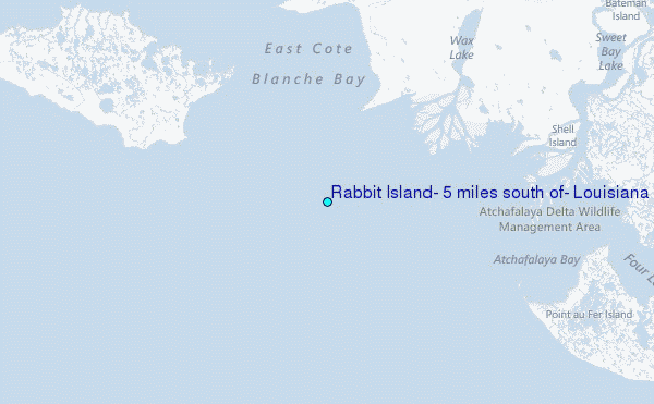
Choose Rabbit Island, 5 miles south of, Louisiana Location Map Zoom:
| Contours: | Roads & Rivers: | Select a
tide station / surf break / city |

Use this relief map to navigate to tide stations, surf breaks and cities that are in the area of Rabbit Island, 5 miles south of, Louisiana.
Other Nearby Locations' tide tables and tide charts to Rabbit Island, 5 miles south of, Louisiana:
click location name for more details
 Surf breaks close to Rabbit Island, 5 miles south of, Louisiana:
|
||
|---|---|---|
| Closest surf break | Holly Beach | 115 mi |
| Second closest surf break | Chandeleur Islands | 168 mi |
| Third closest surf break | Bolivar | 173 mi |
| Fourth closest surf break | Meacom Pier | 189 mi |
| Fifth closest surf break | Galveston - Flagship Pier | 191 mi |


 Nearest
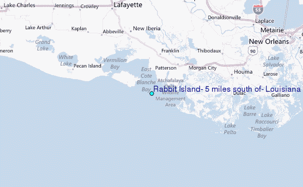