
| Distance / Altitude | Location | Report Date / Time | Live Weather | Wind | Gusts | Temp. | Visibility | Cloud |
|---|---|---|---|---|---|---|---|---|
| 0 km NE / 3 m | BUOY-RDYD1 (Marine) | 2025-12-23 18:00 local (2025/12/23 23:00 GMT) | - (- km/h at -) | 4°C | - | |||
| 3 km NW / 3 m | BUOY-DELD1 (Marine) | 2025-12-23 18:00 local (2025/12/23 23:00 GMT) | calm (2 km/h at 220) | 4°C | - | |||
| 12 km N / 216 m | Wilmington Airport (Delaware) | 2025-12-23 16:51 local (2025/12/23 21:51 GMT) | Dry and cloudy | light winds from the W (6 km/h at 270) | 4°C | 16 | scattered overcast | |
| 18 km WNW / 24 m | Newark (Delaware) | 2025-12-23 18:29 local (2025/12/23 23:29 GMT) | dry | calm (0 km/h at 226) | 3°C | - | - - 0 | |
| 21 km WSW / 3 m | BUOY-CHCM2 (Marine) | 2025-12-23 18:00 local (2025/12/23 23:00 GMT) | calm (4 km/h at 320) | 4°C | - | |||
| 24 km N / 88 m | Greenville (Delaware) | 2025-12-23 18:10 local (2025/12/23 23:10 GMT) | - | calm (0 km/h at 240) | 2°C | - | - - 0 | |
| 25 km NNE / 31 m | Bellevue Hills (Delaware) | 2025-12-23 18:05 local (2025/12/23 23:05 GMT) | dry | calm (0 km/h at 0) | 3°C | - | - - 0 | |
| 27 km N / 300 m | Greenville (Delaware) | 2025-12-23 18:36 local (2025/12/23 23:36 GMT) | - | calm (0 km/h at 359) | 2°C | - | - - 0 | |
| 28 km NW / 103 m | Larchmont wx (United States) | 2025-12-23 18:40 local (2025/12/23 23:40 GMT) | - | calm (0 km/h at 140) | 2°C | - | - - 0 | |
| 29 km NNE / 40 m | Overlook Colony wx (United States) | 2025-12-23 18:24 local (2025/12/23 23:24 GMT) | dry | calm (0 km/h at 0) | 3°C | - | - - 0 |
| Contours: | Roads & Rivers: | Select a
tide station / surf break / city |
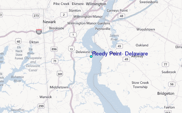
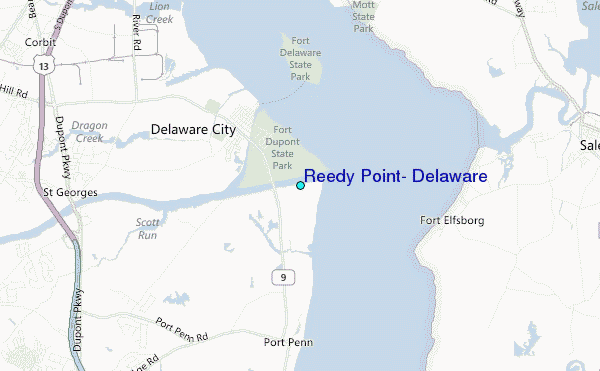
Use this relief map to navigate to tide stations, surf breaks and cities that are in the area of Reedy Point, Delaware.
Other Nearby Locations' tide tables and tide charts to Reedy Point, Delaware:
click location name for more details
 Surf breaks close to Reedy Point, Delaware:
|
||
|---|---|---|
| Closest surf break | Chodes | 55 mi |
| Second closest surf break | 47th Street | 55 mi |
| Third closest surf break | Strathmere 7th Street | 55 mi |
| Fourth closest surf break | Sumner Avenue (Strathmere) | 55 mi |
| Fifth closest surf break | 37th Street Jetty | 55 mi |


 Nearest
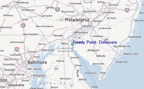