
| Distance / Altitude | Location | Report Date / Time | Live Weather | Wind | Gusts | Temp. | Visibility | Cloud |
|---|---|---|---|---|---|---|---|---|
| 5 km W / 240 m | Cerberus Automatic Weather Station (Australia) | 2026-05-10 10:00 local (2026/05/10 00:00 GMT) | - | - (- km/h at -) | — | - | - - - | |
| 12 km SE / 240 m | Rhyll Automatic Weather Station (Australia) | 2026-05-10 10:00 local (2026/05/10 00:00 GMT) | no report | light winds from the ESE (7 km/h at 110) | 9°C | - | - - - | |
| 26 km NW / 239 m | Frankston (Australia) | 2026-05-10 11:00 local (2026/05/10 01:00 GMT) | - | light winds from the W (11 km/h at 270) | — | - | no observation | |
| 26 km NW / 6 m | Frankston Automatic Weather Station (Australia) | 2026-05-10 10:00 local (2026/05/10 00:00 GMT) | no report | - (- km/h at -) | — | - | - | |
| 37 km NW / 40 m | Chelsea (Australia) | 2026-05-10 11:18 local (2026/05/10 01:18 GMT) | dry | calm (0 km/h at 169) | 21°C | - | - - 0 | |
| 44 km NW / 13 m | MoorabbinAirport (Australia) | 2026-05-10 10:00 local (2026/05/10 00:00 GMT) | Clear skies | calm (0 km/h at 0) | 15°C | - | - overcast - | |
| 53 km NW / 214 m | Fawkner Beacon (Australia) | 2026-05-10 11:00 local (2026/05/10 01:00 GMT) | - | light winds from the SSW (7 km/h at 200) | — | - | no observation | |
| 55 km N / 80 m | Scoresby Research Institute (Australia) | 2026-05-10 11:00 local (2026/05/10 01:00 GMT) | no report | calm (4 km/h at 170) | 15°C | - | - no observation - | |
| 56 km NNE / 513 m | FernyCreek (Australia) | 2026-05-10 10:00 local (2026/05/10 00:00 GMT) | No report | calm (2 km/h at 180) | 10°C | - | - no observation - | |
| 60 km ESE / 4 m | Pound Creek (Australia) | 2026-05-10 11:00 local (2026/05/10 01:00 GMT) | no report | light winds from the NW (7 km/h at 320) | 3°C | - | - no observation - |
| Contours: | Roads & Rivers: | Select a
tide station / surf break / city |
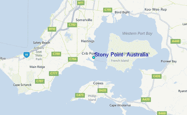
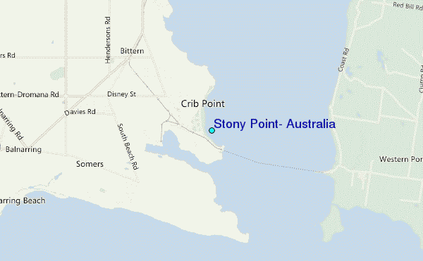
Use this relief map to navigate to tide stations, surf breaks and cities that are in the area of Stony Point, Australia.
Other Nearby Locations' tide tables and tide charts to Stony Point, Australia:
click location name for more details
 Surf breaks close to Stony Point, Australia:
|
||
|---|---|---|
| Closest surf break | Balnarring Point | 6 mi |
| Second closest surf break | Crunchie Pt | 6 mi |
| Third closest surf break | Point Leo | 9 mi |
| Fourth closest surf break | Flynns Reef | 9 mi |
| Fifth closest surf break | Honeysuckle Point | 9 mi |


 Nearest
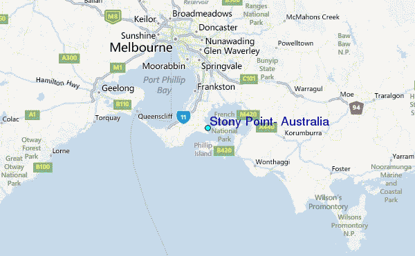