
| Distance / Altitude | Location | Report Date / Time | Live Weather | Wind | Gusts | Temp. | Visibility | Cloud |
|---|---|---|---|---|---|---|---|---|
| 237 km E / 215 m | Kwajalein/buchol Airport (Marshall Islands) | 2025-12-25 14:40 local (2025/12/25 02:40 GMT) | Dry and partly cloudy | light winds from the NNE (19 km/h at 20) | 29°C | 16 | scattered scattered scattered | |
| 237 km E / 3 m | BUOY-KWJP8 (Marine) | 2025-12-25 15:00 local (2025/12/25 03:00 GMT) | - (- km/h at -) | — | - | |||
| 502 km SSW / 178 m | Kosrae Island Airport (Micronesia) | 2025-12-25 13:50 local (2025/12/25 01:50 GMT) | Dry and partly cloudy | light winds from the NE (15 km/h at 50) | 30°C | 16 | broken broken broken | |
| 508 km SSW / 3 m | BUOY-52215 (Marine) | 2025-12-25 15:00 local (2025/12/25 03:00 GMT) | - (- km/h at -) | 29°C | - | |||
| 654 km ESE / 208 m | Majuro Atoll Airport (Marshall Islands) | 2025-12-25 13:55 local (2025/12/25 01:55 GMT) | - | calm (4 km/h at 1) | 31°C | 24 | few | |
| 839 km SW / 3 m | BUOY-52213 (Marine) | 2025-12-25 15:00 local (2025/12/25 03:00 GMT) | - (- km/h at -) | 29°C | - | |||
| 845 km SW / 235 m | Pohnpei Airport (Micronesia) | 2025-12-25 13:51 local (2025/12/25 01:51 GMT) | Dry and cloudy | light winds from the NE (11 km/h at 50) | 29°C | 24 | scattered broken overcast | |
| 1140 km N / 3 m | BUOY-WAKP8 (Marine) | 2025-12-25 15:00 local (2025/12/25 03:00 GMT) | moderate winds from the N (26 km/h at 360) | 25°C | - | |||
| 1140 km N / 194 m | Wake Island Airfield Airport (Wake Island) | 2025-12-25 13:55 local (2025/12/25 01:55 GMT) | Dry and cloudy | moderate winds from the N (26 km/h at 350) | 28°C | 13 | few overcast | |
| 1163 km W / 15 m | SHIP6600 (Marine) | 2025-12-25 13:00 local (2025/12/25 01:00 GMT) | - (- km/h at -) | — | - km |
| Contours: | Roads & Rivers: | Select a
tide station / surf break / city |
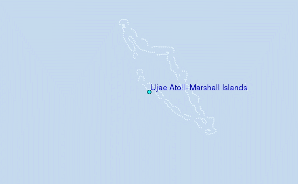
Use this relief map to navigate to tide stations, surf breaks and cities that are in the area of Ujae Atoll, Marshall Islands.
Other Nearby Locations' tide tables and tide charts to Ujae Atoll, Marshall Islands:
click location name for more details
 Surf breaks close to Ujae Atoll, Marshall Islands:
|
||
|---|---|---|
| Closest surf break | Sidedish | 314 mi |
| Second closest surf break | Walung | 316 mi |
| Third closest surf break | Naa | 719 mi |
| Fourth closest surf break | Simberi Island | 1235 mi |
| Fifth closest surf break | Rubio | 1264 mi |


 Nearest