
| Distance / Altitude | Location | Report Date / Time | Live Weather | Wind | Gusts | Temp. | Visibility | Cloud |
|---|---|---|---|---|---|---|---|---|
| 4 km SSW / 4.6 m | Islamorada (Florida) | 2026-07-27 21:07 local (2026/07/28 01:07 GMT) | dry | - (- km/h at ) | — | - | - - 0 | |
| 15 km SSW / 1 m | Marathon (Florida) | 2026-07-27 20:34 local (2026/07/28 00:34 GMT) | dry | - (- km/h at ) | — | - | - - 0 | |
| 27 km SW / 3 m | BUOY-LONF1 (Marine) | 2026-07-27 21:30 local (2026/07/28 01:30 GMT) | light winds from the W (15 km/h at 270) | 30°C | - | |||
| 40 km SW / 1 m | Jolly Roger Travel Park wx (United States) | 2026-07-27 21:41 local (2026/07/28 01:41 GMT) | dry | calm (2 km/h at 244) | 29°C | - | - - 0 | |
| 49 km SW / 5 m | Marathon (Florida) | 2026-07-27 21:31 local (2026/07/28 01:31 GMT) | dry | light winds from the SW (11 km/h at 231) | 29°C | - | - - 0 | |
| 50 km SW / 217 m | Marathon Airport (Florida) | 2026-07-27 19:53 local (2026/07/27 23:53 GMT) | Light rain | calm (0 km/h at 0) | 26°C | 10 | few broken broken | |
| 52 km SW / 2 m | Castle Rock (Colorado) | 2026-07-27 20:37 local (2026/07/28 00:37 GMT) | dry | light winds from the WSW (10 km/h at 253) | 29°C | - | - - 0 | |
| 57 km S / 3 m | SHIP2261 (Marine) | 2026-07-27 19:00 local (2026/07/27 23:00 GMT) | - (- km/h at -) | — | - | |||
| 57 km S / 15 m | SHIP5706 (Marine) | 2026-07-27 19:00 local (2026/07/27 23:00 GMT) | - (- km/h at -) | — | - km | |||
| 57 km S / 3 m | SHIP4436 (Marine) | 2026-07-27 19:00 local (2026/07/27 23:00 GMT) | - (- km/h at -) | — | - |
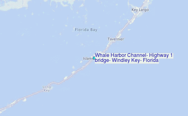
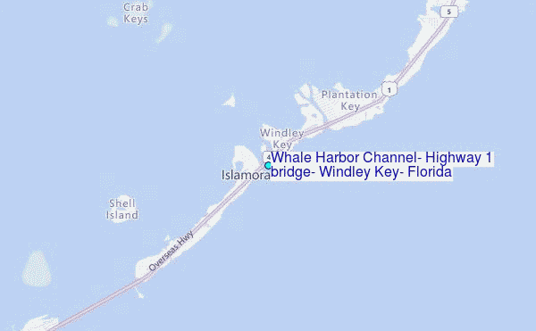
Choose Whale Harbor Channel, Highway 1 bridge, Windley Key, Florida Location Map Zoom:
| Contours: | Roads & Rivers: | Select a
tide station / surf break / city |


Use this relief map to navigate to tide stations, surf breaks and cities that are in the area of Whale Harbor Channel, Highway 1 bridge, Windley Key, Florida.
Other Nearby Locations' tide tables and tide charts to Whale Harbor Channel, Highway 1 bridge, Windley Key, Florida:
click location name for more details
 Surf breaks close to Whale Harbor Channel, Highway 1 bridge, Windley Key, Florida:
|
||
|---|---|---|
| Closest surf break | South Beach (Miami) | 65 mi |
| Second closest surf break | Fifth Street (Miami) | 65 mi |
| Third closest surf break | 21st Street (Miami) | 67 mi |
| Fourth closest surf break | Dunes Hotel (Miami) | 68 mi |
| Fifth closest surf break | Harbor House | 73 mi |


 Nearest
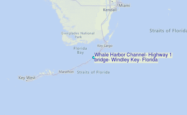