
| Distance / Altitude | Location | Report Date / Time | Live Weather | Wind | Gusts | Temp. | Visibility | Cloud |
|---|---|---|---|---|---|---|---|---|
| 83 km S / 250 m | Bangsan RWS Airport (South Korea) | 2024-05-03 01:10 local (2024/05/02 16:40 GMT) | Clear | calm (2 km/h at 130) | 9°C | 10.0 | ||
| 88 km S / 197 m | Gimwa Rws Airport (South Korea) | 2024-05-03 01:10 local (2024/05/02 16:40 GMT) | Clear | calm (2 km/h at 120) | 9°C | 10.0 | ||
| 97 km S / 710 m | Yangku Airport (Korea) | 2024-05-03 00:30 local (2024/05/02 16:00 GMT) | Dry and partly cloudy | light winds from the W (19 km/h at 260) | 19°C | 10.0 | no cloud | |
| 97 km SE / 242 m | Sokcho (South Korea) | 2024-05-03 00:30 local (2024/05/02 16:00 GMT) | no report | calm (2 km/h at 70) | 15°C | 50 km | - clear - | |
| 103 km S / 155 m | Cheorwon (South Korea) | 2024-05-03 00:30 local (2024/05/02 16:00 GMT) | no report | calm (0 km/h at 330) | 11°C | 9 | - clear - |
| Contours: | Roads & Rivers: | Select a
tide station / surf break / city |
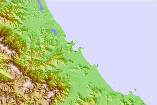
Use this relief map to navigate to tide stations, surf breaks and cities that are in the area of Kojo.
Other Nearby Locations' tide tables and tide charts to Kojo:
click location name for more details
 Surf breaks close to Kojo:
|
||
|---|---|---|
| Closest surf break | Songdojin ni | 35 mi |
| Second closest surf break | 38 Line | 80 mi |
| Third closest surf break | Ingu Beach | 81 mi |
| Fourth closest surf break | Jumunjin | 90 mi |
| Fifth closest surf break | Gyongpo Beach | 96 mi |

 Nearest