
| Distance / Altitude | Location | Report Date / Time | Live Weather | Wind | Gusts | Temp. | Visibility | Cloud |
|---|---|---|---|---|---|---|---|---|
| 1 km S / 360 m | Barahona Airport (Dominican Republic) | 2026-07-09 14:00 local (2026/07/09 18:00 GMT) | - | fresh winds from the SE (30 km/h at 130) | 32°C | 10.0 | few few scattered | |
| 53 km E / 0 m | lightning 17km SSW of Sabana Buey (Dominican Republic) | 2026-07-09 15:17 local (2026/07/09 19:17 GMT) | Thunderstorm | (- km/h at -) | — | |||
| 70 km N / 720 m | lightning 7km N of Bohechio (Dominican Republic) | 2026-07-09 13:47 local (2026/07/09 17:47 GMT) | Thunderstorm | (- km/h at -) | — | |||
| 92 km NE / 951 m | lightning 15km E of Tireo Arriba (Dominican Republic) | 2026-07-09 14:48 local (2026/07/09 18:48 GMT) | Thunderstorm | (- km/h at -) | — | |||
| 94 km NE / 995 m | lightning 9km SSW of Juan Adrian (Dominican Republic) | 2026-07-09 13:19 local (2026/07/09 17:19 GMT) | Thunderstorm | (- km/h at -) | — | |||
| 95 km NE / 707 m | lightning 14km WSW of Bonao (Dominican Republic) | 2026-07-09 13:47 local (2026/07/09 17:47 GMT) | Thunderstorm | (- km/h at -) | — | |||
| 101 km ENE / 1208 m | lightning 10km WSW of Villa Altagracia (Dominican Republic) | 2026-07-09 13:00 local (2026/07/09 17:00 GMT) | Thunderstorm | (- km/h at -) | — | |||
| 123 km W / 1225 m | lightning 6km E of Kenscoff (Haiti) | 2026-07-09 14:02 local (2026/07/09 18:02 GMT) | Thunderstorm | (- km/h at -) | — | |||
| 125 km ENE / 30 m | La Isabela International Airport (Dominican republic) | 2026-07-09 14:00 local (2026/07/09 18:00 GMT) | Thunderstorm light rain thunderstorm | calm (0 km/h at 0) | 26°C | 7.0 | few broken broken | |
| 125 km ENE / 50 m | Bella Vista wx (Dominican Republic) | 2026-07-09 15:02 local (2026/07/09 19:02 GMT) | dry | calm (2 km/h at 17) | 29°C | - | - - 0 |
| Contours: | Roads & Rivers: | Select a
tide station / surf break / city |


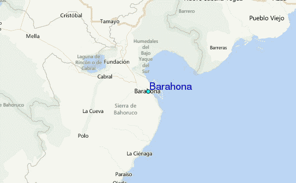
Use this relief map to navigate to tide stations, surf breaks and cities that are in the area of Barahona.
Other Nearby Locations' tide tables and tide charts to Barahona:
click location name for more details
 Surf breaks close to Barahona:
|
||
|---|---|---|
| Closest surf break | Baorvco | 6 mi |
| Second closest surf break | Barranca | 16 mi |
| Third closest surf break | La Cienega | 25 mi |
| Fourth closest surf break | San Rafael | 30 mi |
| Fifth closest surf break | Paraiso | 32 mi |


 Nearest