
| Distance / Altitude | Location | Report Date / Time | Live Weather | Wind | Gusts | Temp. | Visibility | Cloud |
|---|---|---|---|---|---|---|---|---|
| 12 km SSW / 5 m | Glendowie (New Zealand) | 2026-07-10 11:00 local (2026/07/09 23:00 GMT) | Dry | light winds from the SE (11 km/h at 135) | 11°C | - | - - - | |
| 12 km SSE / 50 m | Maraetai School Road (New Zealand) | 2026-07-10 11:04 local (2026/07/09 23:04 GMT) | No weather report | wind obs. (6 kph from 225 degs) was rejected (- km/h at -) | 13°C | - | - - - | |
| 14 km SSW / 27 m | Ftony (New Zealand) | 2026-07-10 11:00 local (2026/07/09 23:00 GMT) | Dry | light winds from the SW (11 km/h at 225) | 13°C | - | - - - | |
| 14 km S / 18 m | Howick (New Zealand) | 2026-07-10 11:05 local (2026/07/09 23:05 GMT) | Dry | light winds from the SW (7 km/h at 225) | 13°C | - | - - - | |
| 14 km ESE / 7 m | Passage Rock Automatic Weather Station (New Zealand) | 2026-07-10 11:10 local (2026/07/09 23:10 GMT) | No weather report | moderate winds from the S (22 km/h at 180) | — | - | - - - | |
| 16 km SSW / 9 m | Morepork Manor- Meadowbank (New Zealand) | 2026-07-10 11:00 local (2026/07/09 23:00 GMT) | Dry | light winds from the S (9 km/h at 180) | 13°C | - | - - - | |
| 20 km WSW / 15 m | Beach Road Castor Bay (New Zealand) | 2026-07-10 11:03 local (2026/07/09 23:03 GMT) | No weather report | calm (2 km/h at 135) | 15°C | - | - - - | |
| 21 km S / 22 m | Mission Heights (New Zealand) | 2026-07-10 11:00 local (2026/07/09 23:00 GMT) | Dry | calm (0 km/h at 315) | — | - | - - - | |
| 22 km NW / 36 m | Tiritiri Light Automatic Weather Station (New Zealand) | 2026-07-10 11:10 local (2026/07/09 23:10 GMT) | No weather report | light winds from the S (19 km/h at 180) | — | - | - - - | |
| 22 km SW / 8 m | Auckland Harbour Bridge (New Zealand) | 2026-07-10 11:10 local (2026/07/09 23:10 GMT) | No weather report | light winds from the S (13 km/h at 180) | 13°C | - | - - - |
| Contours: | Roads & Rivers: | Select a
tide station / surf break / city |
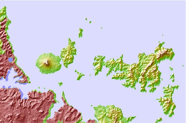
Use this relief map to navigate to tide stations, surf breaks and cities that are in the area of Matiatia Bay, New Zealand.
Other Nearby Locations' tide tables and tide charts to Matiatia Bay, New Zealand:
click location name for more details
 Surf breaks close to Matiatia Bay, New Zealand:
|
||
|---|---|---|
| Closest surf break | Waiheke Island | 5 mi |
| Second closest surf break | Milford Beach | 11 mi |
| Third closest surf break | Takapuna-North Reef | 13 mi |
| Fourth closest surf break | Browns Bay Bar | 14 mi |
| Fifth closest surf break | Long Bay Reef | 14 mi |


 Nearest