
| Distance / Altitude | Location | Report Date / Time | Live Weather | Wind | Gusts | Temp. | Visibility | Cloud |
|---|---|---|---|---|---|---|---|---|
| 30 km WSW / 3 m | BUOY-CDXA2 (Marine) | 2026-06-23 13:32 local (2026/06/23 21:32 GMT) | light winds from the NW (18 km/h at 320) | 10°C | - | |||
| 30 km WSW / 3 m | BUOY-CDEA2 (Marine) | 2026-06-23 13:22 local (2026/06/23 21:22 GMT) | light winds from the W (17 km/h at 280) | 14°C | - | |||
| 56 km SE / 206 m | Klawock Airport (Alaska) | 2026-06-23 11:53 local (2026/06/23 19:53 GMT) | - | wind obs. (19 kph from 200 degs) was rejected (- km/h at -) | 19°C | 16 | few | |
| 62 km ENE / 3 m | BUOY-LCNA2 (Marine) | 2026-06-23 13:10 local (2026/06/23 21:10 GMT) | moderate winds from the NNW (21 km/h at 340) | 18°C | - | |||
| 63 km SSE / 3 m | BUOY-CRGA2 (Marine) | 2026-06-23 13:24 local (2026/06/23 21:24 GMT) | calm (5 km/h at 10) | 15°C | - | |||
| 70 km W / 3 m | BUOY-PLXA2 (Marine) | 2026-06-23 13:00 local (2026/06/23 21:00 GMT) | calm (2 km/h at 30) | 16°C | - | |||
| 92 km ENE / 243 m | Thoms Place wx (United States) | 2026-06-23 13:45 local (2026/06/23 21:45 GMT) | dry | calm (5 km/h at 55) | 19°C | - | - - 0 | |
| 99 km SSE / 215 m | Hydaburg Airport (Alaska) | 2026-06-23 11:56 local (2026/06/23 19:56 GMT) | Clear | light winds from the S (9 km/h at 190) | 16°C | 16 | ||
| 99 km NNE / 46 m | Scow Bay wx (United States) | 2026-06-23 13:04 local (2026/06/23 21:04 GMT) | dry | calm (0 km/h at 180) | 24°C | - | - - 0 | |
| 99 km NE / 3 m | BUOY-WGXA2 (Marine) | 2026-06-23 13:32 local (2026/06/23 21:32 GMT) | light winds from the W (9 km/h at 270) | 15°C | - |
| Contours: | Roads & Rivers: | Select a
tide station / surf break / city |
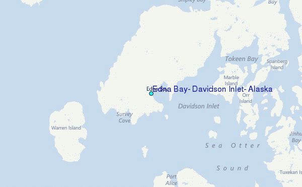
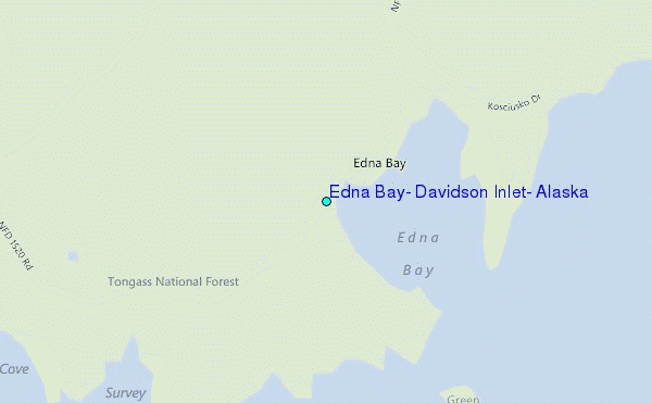
Use this relief map to navigate to tide stations, surf breaks and cities that are in the area of Edna Bay, Davidson Inlet, Alaska.
Other Nearby Locations' tide tables and tide charts to Edna Bay, Davidson Inlet, Alaska:
click location name for more details
 Surf breaks close to Edna Bay, Davidson Inlet, Alaska:
|
||
|---|---|---|
| Closest surf break | Lepus Beach (Haida-Gwaii) | 126 mi |
| Second closest surf break | Tow Hill Beach | 149 mi |
| Third closest surf break | Cannon Beach | 333 mi |
| Fourth closest surf break | Graveyards | 336 mi |
| Fifth closest surf break | Ocean Cape | 337 mi |


 Nearest
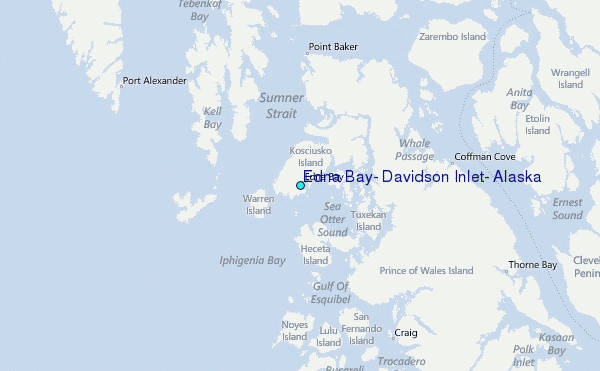