
Khyex Point Sea Conditions table showing wave height, swell direction and period.
High and low tide times are also provided on the table along with the moon phase and forecast weather. Sunrise today is at 05:41 AM and sunset is at 09:49 PM.
Days 1–3 Weather SummaryHeavy rain (total 32mm), heaviest during Mon night. Cool air temperatures (max 17°C on Mon afternoon, min 12°C on Sun morning). Wind will be generally light. | Days 4–6 Weather SummaryHeavy rain (total 24mm), heaviest during Fri afternoon. Cool air temperatures (max 19°C on Thu afternoon, min 11°C on Fri night). Wind will be generally light. | Days 7–9 Weather SummaryLight rain (total 9mm), mostly falling on Sat morning. Warm (max 24°C on Mon afternoon, min 10°C on Sun night). Wind will be generally light. | Days 10–12 Weather SummaryHeavy rain (total 34mm), heaviest during Wed morning. Warm (max 21°C on Thu afternoon, min 12°C on Thu night). Wind will be generally light. | Days 13–16 Weather SummaryHeavy rain (total 30mm), heaviest during Sun night. Warm (max 25°C on Fri afternoon, min 12°C on Mon night). Wind will be generally light. | |||||||||||||||||||||||||||||||||||||||||||
Sunday 26 | Monday 27 | Tuesday 28 | Wednesday 29 | Thursday 30 | Friday 31 | Saturday 1 | Sunday 2 | Monday 3 | Tuesday 4 | Wednesday 5 | Thursday 6 | Friday 7 | Saturday 8 | Sunday 9 | Mon 10 | ||||||||||||||||||||||||||||||||
AM | PM | night | AM | PM | night | AM | PM | night | AM | PM | night | AM | PM | night | AM | PM | night | AM | PM | night | AM | PM | night | AM | PM | night | AM | PM | night | AM | PM | night | AM | PM | night | AM | PM | night | AM | PM | night | AM | PM | night | AM | PM | |
Wave Height Map | 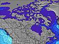 | 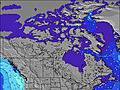 | 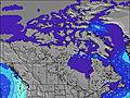 | 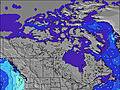 | 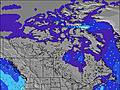 | 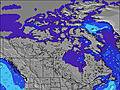 | 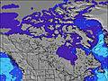 | 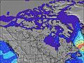 | 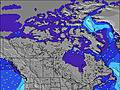 | 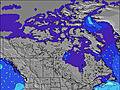 | 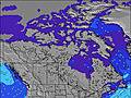 | 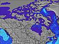 | 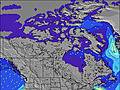 | 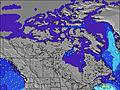 | 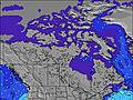 | 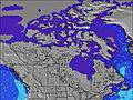 | |||||||||||||||||||||||||||||||
High Tide | 4:10PM3.86m | 1:26AM4.58m | 4:05PM3.94m | 2:11AM4.79m | 3:50PM4.10m | 2:50AM4.99m | 4:02PM4.30m | 3:27AM5.14m | 4:25PM4.52m | 4:03AM5.21m | 4:52PM4.72m | 4:40AM5.18m | 5:22PM4.90m | 5:18AM5.06m | 5:53PM5.04m | 5:58AM4.84m | 6:28PM5.12m | 6:42AM4.53m | 7:07PM5.13m | 7:32AM4.15m | 7:51PM5.06m | 8:33AM3.76m | 8:45PM4.95m | 9:49AM3.47m | 9:52PM4.84m | 11:25AM3.41m | 11:10PM4.86m | 1:14PM3.69m | |||||||||||||||||||
Low Tide | 8:31AM1.01m | 8:33PM2.51m | 9:11AM0.80m | 9:14PM2.31m | 9:47AM0.62m | 9:50PM2.13m | 10:20AM0.52m | 10:24PM1.98m | 10:50AM0.49m | 10:57PM1.86m | 11:18AM0.56m | 11:29PM1.77m | 11:43AM0.73m | 00:00AM1.70m | 12:02PM0.97m | 00:32AM1.66m | 12:16PM1.26m | 1:11AM1.65m | 12:25PM1.58m | 2:06AM1.68m | 12:39PM1.92m | 3:28AM1.68m | 1:03PM2.30m | 4:58AM1.54m | 1:37PM2.72m | 6:16AM1.20m | 6:13PM2.82m | 7:20AM0.76m | |||||||||||||||||||
Wave Height (m) Direction Period (s) | — | — | — | — | — | — | — | — | — | — | — | — | — | — | — | — | — | — | — | — | — | — | — | — | — | — | — | — | — | — | — | — | — | — | — | — | — | — | — | — | — | — | — | — | — | — | — |
light rain | light rain | rain shwrs | some clouds | light rain | heavy rain | rain shwrs | light rain | light rain | light rain | rain shwrs | rain shwrs | light rain | cloudy | light rain | mod rain | mod rain | rain shwrs | light rain | light rain | cloudy | light rain | some clouds | clear | clear | some clouds | cloudy | cloudy | light rain | heavy rain | heavy rain | rain shwrs | rain shwrs | some clouds | some clouds | clear | clear | clear | some clouds | some clouds | cloudy | cloudy | some clouds | cloudy | heavy rain | light rain | mod rain | |
km/h | |||||||||||||||||||||||||||||||||||||||||||||||
mm | 3 | 3 | 2 | — | 1 | 16 | 1 | 2 | 4 | 2 | 2 | 1 | 2 | — | 1 | 6 | 8 | 2 | 3 | 3 | — | 3 | — | — | — | — | — | — | 1 | 14 | 14 | 3 | 2 | — | — | — | — | — | — | — | — | — | — | — | 16 | 5 | 8 |
max °C | 14 | 16 | 15 | 15 | 17 | 13 | 15 | 14 | 13 | 13 | 16 | 16 | 15 | 19 | 17 | 12 | 14 | 14 | 13 | 13 | 13 | 12 | 15 | 17 | 19 | 24 | 19 | 17 | 18 | 17 | 17 | 19 | 17 | 17 | 21 | 19 | 20 | 25 | 20 | 21 | 23 | 16 | 17 | 22 | 20 | 16 | 14 |
Moonrise | — | 8:56 | — | — | — | 9:27 | — | — | 9:48 | — | — | 10:03 | — | — | 10:14 | — | — | 10:23 | — | — | 10:31 | — | — | 10:39 | — | — | 10:48 | — | — | 11:00 | — | — | 11:16 | — | — | 11:40 | — | — | — | 12:19 | — | — | 1:21 | — | — | 2:44 | — |
Moonset | 2:01 | — | — | 3:02 | — | — | 4:15 | — | — | 5:34 | — | — | 6:54 | — | — | 8:14 | — | — | 9:33 | — | — | 10:53 | — | — | 12:14 | — | — | 1:39 | — | — | — | 3:09 | — | — | 4:41 | — | — | 6:09 | — | — | 7:23 | — | — | 8:14 | — | — | 8:46 |
5:41 | — | — | 5:41 | — | — | 5:43 | — | — | 5:46 | — | — | 5:47 | — | — | 5:48 | — | — | 5:50 | — | — | 5:52 | — | — | 5:54 | — | — | 5:56 | — | — | 5:56 | — | — | 5:58 | — | — | 6:01 | — | — | 6:03 | — | — | 6:03 | — | — | 6:05 | — | |
— | — | 9:49 | — | — | 9:46 | — | — | 9:45 | — | — | 9:44 | — | — | 9:42 | — | — | 9:39 | — | — | 9:37 | — | — | 9:37 | — | — | 9:35 | — | — | 9:32 | — | — | 9:30 | — | — | 9:29 | — | — | 9:27 | — | — | 9:24 | — | — | 9:22 | — | 9:21 | |
Today's sea temperature in Khyex Point is 13.7° C (Statistics for 26 Jul 1981-2005 – mean: 13.7 max: 15.3 min: 12.2°C) | |||||||||||||||||||||||||||||||||||||||||||||||


 Nearest