
Upper Attawaspiskat Sea Conditions table showing wave height, swell direction and period.
High and low tide times are also provided on the table along with the moon phase and forecast weather. Sunrise today is at — and sunset is at 08:54 PM.
Days 1–4 Weather SummaryMostly dry. Icy conditions (max 3°C on Sat afternoon, min -6°C on Thu night). Wind will be generally light. | Days 5–7 Weather SummaryMild at first with light rain (total 3mm) on Sun afternoon followed by colder weather and light fall of snow, heaviest on Mon night. Icy conditions (max 3°C on Sun afternoon, min 0°C on Mon morning). Winds decreasing (fresh winds from the NNW on Mon night, calm by Wed morning). | Days 8–10 Weather SummaryMostly dry. Freeze-thaw conditions (max 3°C on Fri afternoon, min -2°C on Wed night). Wind will be generally light. | Days 11–13 Weather SummaryMostly dry. Freeze-thaw conditions (max 9°C on Mon night, min -1°C on Sun morning). Wind will be generally light. | ||||||||||||||||||||||||||||||||||||||||||||
Thu 30 | Friday 1 | Saturday 2 | Sunday 3 | Monday 4 | Tuesday 5 | Wednesday 6 | Thursday 7 | Friday 8 | Saturday 9 | Sunday 10 | Monday 11 | Tuesday 12 | Wednesday 13 | Thursday 14 | Friday 15 | ||||||||||||||||||||||||||||||||
PM | night | AM | PM | night | AM | PM | night | AM | PM | night | AM | PM | night | AM | PM | night | AM | PM | night | AM | PM | night | AM | PM | night | AM | PM | night | AM | PM | night | AM | PM | night | AM | PM | night | AM | PM | night | AM | PM | night | AM | PM | night | |
Wave Height Map | 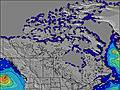 | 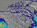 | 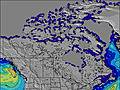 | 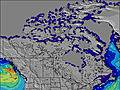 | 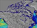 | 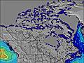 | 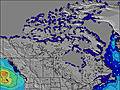 |  | 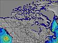 | 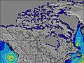 | 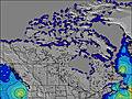 | 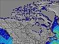 | 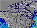 | 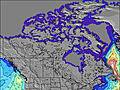 | 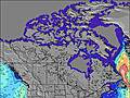 | 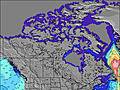 | |||||||||||||||||||||||||||||||
High Tide | 6:48PM0.53m | 6:52AM0.60m | 7:20PM0.58m | 7:08AM0.64m | 7:38PM0.64m | 7:25AM0.68m | 7:58PM0.70m | 7:46AM0.74m | 8:21PM0.77m | 8:11AM0.80m | 8:49PM0.83m | 8:42AM0.85m | 9:23PM0.87m | 9:19AM0.86m | 10:01PM0.87m | 10:02AM0.83m | 10:44PM0.83m | 10:50AM0.76m | 11:28PM0.78m | 11:42AM0.69m | 00:14AM0.73m | 12:38PM0.63m | 1:00AM0.69m | 1:35PM0.59m | 1:50AM0.66m | 2:34PM0.57m | 2:46AM0.64m | 3:35PM0.57m | |||||||||||||||||||
Low Tide | 1:05PM0.08m | 1:22AM0.16m | 1:57PM0.04m | 2:06AM0.11m | 2:35PM0.03m | 2:36AM0.09m | 3:03PM0.04m | 2:57AM0.08m | 3:24PM0.06m | 3:11AM0.08m | 3:35PM0.06m | 3:19AM0.06m | 3:22PM0.06m | 3:36AM0.06m | 3:36PM0.06m | 4:12AM0.07m | 5:23PM0.08m | 5:31AM0.10m | 6:44PM0.09m | 7:07AM0.11m | 7:32PM0.09m | 8:05AM0.10m | 8:03PM0.11m | 8:50AM0.09m | 8:13PM0.13m | 9:24AM0.11m | 8:26PM0.14m | 9:40AM0.13m | |||||||||||||||||||
NNW 2 | N 2 | NNW 2 | NNW 2 | NNW 2 | NW 2 | NW 2 | W 1 | SE 2 | SE 2 | W 1 | W 1 | NE 1 | N 3 | NNW 3 | NW 2 | NW 2 | E 2 | E 1 | E 1 | N 2 | E 1 | E 2 | E 1 | E 1 | E 2 | E 2 | E 1 | S 1 | N 1 | E 2 | E 2 | W 1 | W 1 | W 1 | N 1 | NE 2 | NE 2 | N 2 | NNE 2 | N 2 | N 1 | N 1 | E 2 | W 1 | W 1 | N 1 | |
cloudy | cloudy | cloudy | cloudy | cloudy | cloudy | cloudy | some clouds | cloudy | light rain | cloudy | some clouds | cloudy | light snow | light snow | light snow | light snow | light snow | cloudy | cloudy | cloudy | cloudy | cloudy | cloudy | some clouds | some clouds | cloudy | cloudy | some clouds | some clouds | cloudy | some clouds | some clouds | cloudy | some clouds | clear | some clouds | some clouds | cloudy | cloudy | some clouds | cloudy | light rain | cloudy | cloudy | cloudy | cloudy | |
km/h | |||||||||||||||||||||||||||||||||||||||||||||||
— | — | — | — | — | — | — | — | — | 3 | — | — | — | — | — | — | — | — | — | — | — | — | — | — | — | — | — | — | — | — | — | — | — | — | — | — | — | — | — | — | — | — | 1 | — | — | — | — | |
max°C | -1 | -2 | -3 | -1 | -2 | -2 | 3 | 3 | 3 | 3 | 2 | 2 | 3 | 1 | 1 | 2 | 1 | 1 | 1 | 0 | 0 | 2 | 1 | 1 | 3 | 0 | 0 | 3 | 2 | 1 | 5 | 4 | 5 | 8 | 9 | 6 | 8 | 1 | 3 | 5 | 3 | 5 | 5 | 4 | 4 | 7 | 6 |
Moonrise | 8:21 | — | — | — | 9:38 | — | — | 10:54 | — | — | — | 12:05 | — | — | 1:06 | — | — | 1:54 | — | — | 2:29 | — | — | 2:53 | — | — | 3:11 | — | — | 3:25 | — | — | 3:36 | — | — | 3:47 | — | — | 3:57 | — | — | 4:09 | — | — | 4:24 | — | — |
Moonset | — | — | 5:23 | — | — | 5:39 | — | — | 6:02 | — | — | 6:33 | — | — | 7:18 | — | — | 8:16 | — | — | 9:25 | — | — | 10:40 | — | — | 11:58 | — | — | 1:17 | — | — | 2:37 | — | — | — | 3:59 | — | — | 5:24 | — | — | 6:54 | — | — | 8:29 | — |
— | — | 5:56 | — | — | 5:54 | — | — | 5:52 | — | — | 5:52 | — | — | 5:50 | — | — | 5:48 | — | — | 5:46 | — | — | 5:43 | — | — | 5:41 | — | — | 5:39 | — | — | 5:39 | — | — | 5:37 | — | — | 5:35 | — | — | 5:33 | — | — | 5:31 | — | — | |
8:54 | — | — | 8:57 | — | — | 8:58 | — | — | — | 9:00 | — | — | 9:01 | — | — | 9:02 | — | — | 9:05 | — | — | 9:07 | — | — | 9:08 | — | — | 9:09 | — | — | 9:12 | — | — | 9:14 | — | — | 9:15 | — | — | 9:16 | — | — | 9:19 | — | — | 9:20 | |
Today's sea temperature in Upper Attawaspiskat is -1.3° C (Statistics for 30 Apr 1981-2005 – mean: -1.1 max: -0.2 min: -1.6°C) | |||||||||||||||||||||||||||||||||||||||||||||||


 Nearest